
I-80/SR 65 Interchange
Placer County Transportation Planning Agency (PCTPA), along with Caltrans District 3, Federal Highway Administration (FHWA), the cities of Lincoln, Rocklin, Roseville, and the County of Placer, are project partners for the I-80/SR 65 Interchange Improvements Project. The interchange sits at a major crossroads for Placer County, and the increasing congestion and backups at this facility have negative impacts for our mobility, goods movement, economic development, and quality of life. For these reasons, the improvement to this interchange is a top priority project for PCTPA.
Both federal and state environmental approvals were secured in September 2016, which included Phases 1, 2, and 3. The Phase 1 improvements included adding a third lane on northbound Highway 65 from Interstate 80 to Pleasant Grove Boulevard and adding improvements to the Galleria Boulevard/Stanford Ranch Road interchange. Phase 1 was completed in 2019.
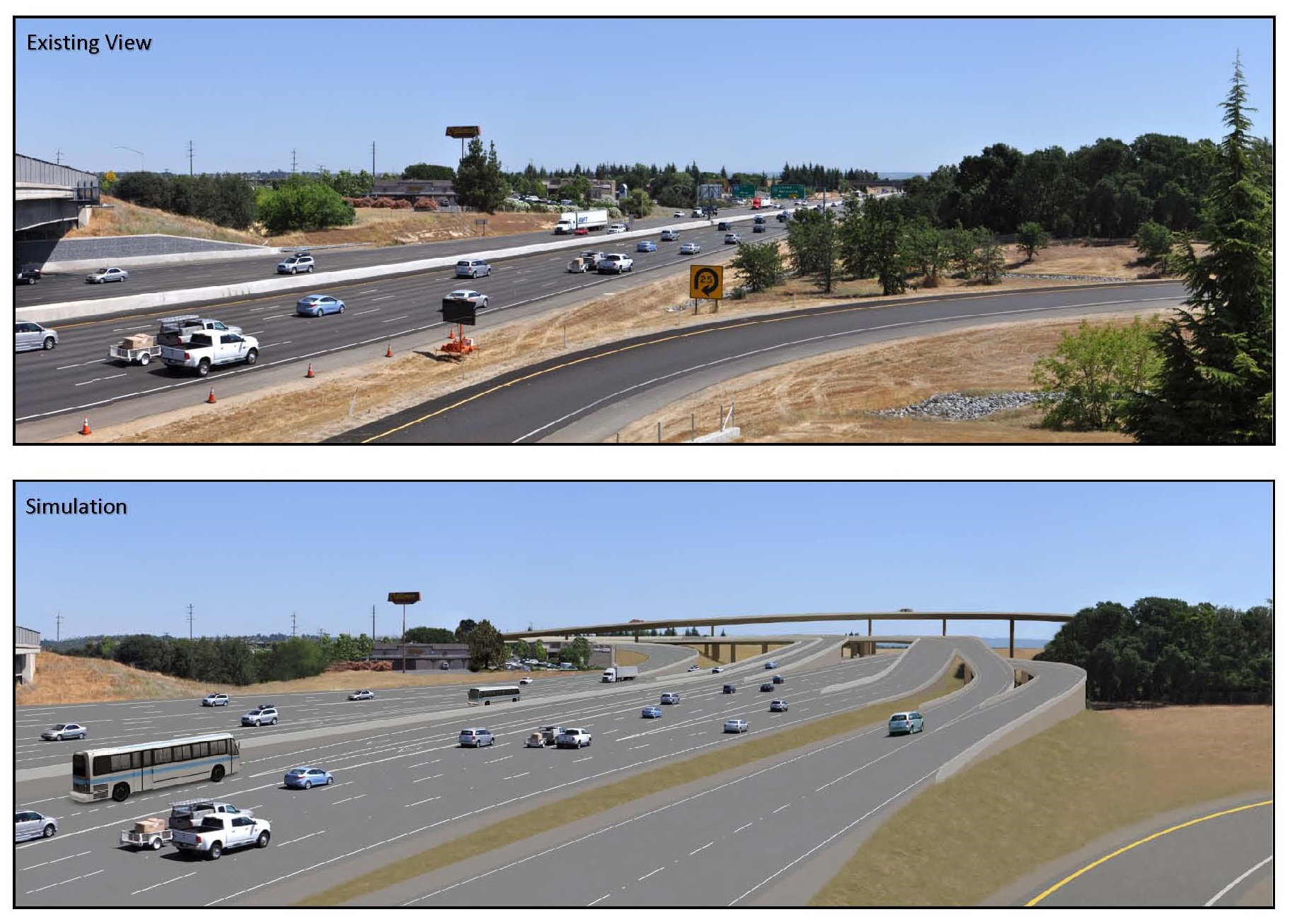
Future improvements will eliminate the eastbound to northbound loop ramp in favor of a direct connections between Highway 65 and Interstate 80. They also include maintaining the existing Interstate 80 access at Taylor Road and eliminating the weaving movements on Interstate 80 eastbound between Eureka Road and Highway 65.
Click here to download a photo simulation of the proposed improvements to eastbound I-80. With the proposed improvements, the existing Taylor Road interchange access will be maintained.
Project Benefits
Existing Traffic Congestion
Today, congestion on eastbound Interstate 80 during the evening commute backs up from Highway 65 more than 3 miles to past Douglas Boulevard. It is estimated that Interstate 80 carries $4.7 million dollars an hour in goods movement, while the Highway 65 corridor is the region’s home to a burgeoning commercial and professional business district. Designed more than 40 years ago, the Interstate 80/State Route 65 interchange is now a bottleneck impeding the flow of traffic on both corridors.
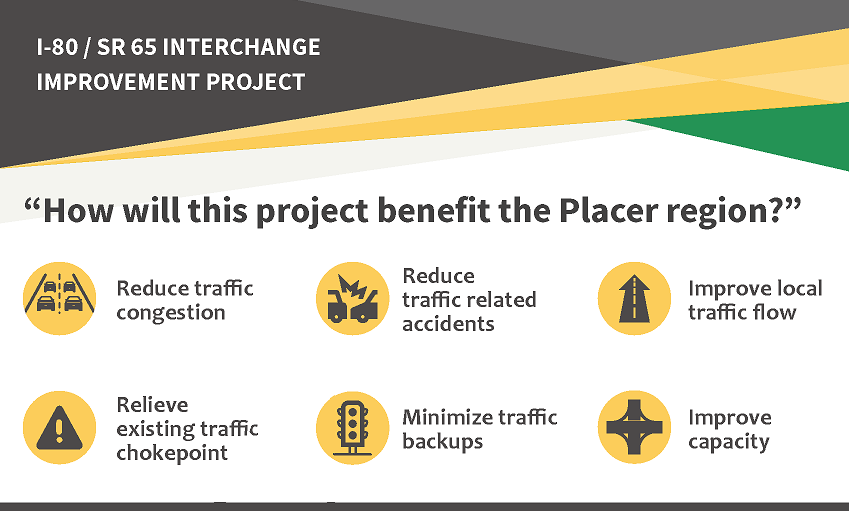
Interchange Project Benefits
All modern economies are dependent upon transportation to move people and goods to and from other economies. In Placer County, Interstate 80 and Highway 65 are two major transportation conduits providing goods and people movement as well as local business access. While traffic within the area is congested especially during peak hours, it is getting a lot worse. The Placer County Transportation Planning Agency (PCTPA) is working on modernizing the interchange to improve both travelers’ safety and traffic flow for the region and protecting the region’s economic future.
Experiencing traffic congestion on a daily basis can dramatically impact the quality of life in Placer County. Sitting in traffic is stressful and means less personal time to enjoy life. Daily traffic congestion creates unpredictable commutes since you are never sure how long your drive to and from work will take you. The resulting reduction in traffic congestion with the Interstate 80/Highway 65 interchange project will improve the reliability of driver commutes.
Without improvements to the Interstate 80/Highway 65 interchange, the average evening commute from Interstate-80 at Riverside Avenue/Auburn Boulevard to Highway 65 at Blue Oaks Boulevard is expected to more than triple within eight years, from 9 minutes to 35 minutes. Upon project completion, the same evening commute will take about 7 minutes.
In addition, with the improved traffic flow in the project area, the number of congestion related accidents will decrease, which is expected to result in overall improved safety. Even with existing and additional growth in traffic, by 2040 the Interstate 80/ State Route 65 Interchange project will reduce delay for travelers in south Placer County during the morning and evening peak periods. The benefit of these improvements for the local economy is estimated at $77 million annually in time savings.
Project Schedule
PCTPA, Placer County, and the adjacent cities do not have the $680 million necessary to improve this state facility. PCTPA continues to pursue state and federal funding, but due to these funding uncertainties, there isn't a firm timeline for constructing the improvements. The overall project will be designed and constructed in phases, as money becomes available. The time to complete the overall project may take 20 years or more depending on available funding.
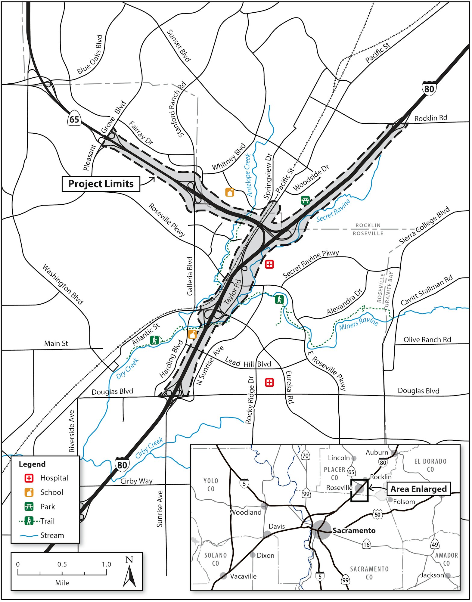
Project Vicinity Map
Project Partners
